


 Neighborhood
What is a neighborhood? Neighborhoods, an Anglo-Saxon word, *neahgebur, or *nigh-dweller, denote physical proximity, closeness, and neighborliness, or knowing persons as friends. Since the beginning of time, this condition has occurred across all cultures, in both urban and rural landscapes. Knowing your neighbors begins simply by meeting the people who live on either side of you or across the street. You may attend a neighborhood school and meet other families in the area. You may become familiar with the people in the grocery store, hardware store, coffee shop, library, or local bakery. You may know some of the pets on your block. As you begin to know people and pets, you can help each other. Borrow a cup of sugar, make a meal for a sick person nearby, shovel an elderly person’s walk, dog-sit, or house-sit if people are traveling. Neighborhoods are communities where people feel a sense of belonging. What makes a good neighbor?
Activity 1 – Walking and Mapping Your Neighborhood
An excellent way to discover a neighborhood is to walk through it. As you walk, look for places where people live. You may find single-family homes, duplexes, triplexes, quadplexes, and apartment buildings. Neighborhoods also offer destinations such as libraries, preschools, elementary, middle, and high schools, and even universities. Healthy neighborhoods provide commercial services such as grocery stores, coffee shops, bakeries, bookstores, barbershops, doctors’ offices, banks, and beauty salons. Green neighborhoods offer squares, parks, and recreational fields for sitting, gathering, playing sports, and meeting others. After walking your neighborhood, draw a mental map of what you remember from North to South and East to West. Where does your neighborhood begin, and where does it end? Are there central boulevards? Label the major streets and key destinations. Place a north arrow on the lower right-hand corner. Upload your mental map of your neighborhood to the gallery.
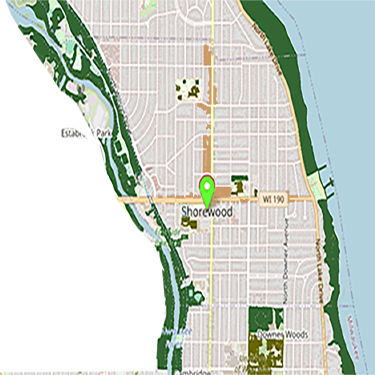
Activity 2 – Key Entries and Routes in your Neighborhood
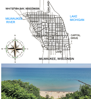
Look up your neighborhood in Google Maps. Locate key entries. Print the Google Map identifying blocks. Most neighborhoods have commercial corridors, boulevards, avenues, and streets. Draw and label them. Check out NEXT.cc’s Streets Journey to learn about different scales of streets. Check whether your neighborhood has dedicated bike lanes. state roads, commercial corridors. Note traffic lights and key pedestrian crossings that slow traffic and protect pedestrians and bikers. Color Boulevards with shady, planted areas where family and friends can gather. Feature alleyways as passageways and garages. Take daily walks. Begin to know the houses and the buildings, the landmarks and the green spaces, the commercial offerings, and the people. Learn about yourself and your relationship to the world right in the very place where you were born and grew up.
What is your favorite place in your neighborhood?
Activity 3 – Neighborhood Amenities
Neighborhoods exist as small villages, complete with everything people of all ages need. They have houses in which to live, schools in which to learn, stores in which to buy food and necessities, restaurants, places to learn, and places to enjoy.
These amenities provide people with destinations to enjoy and contribute to the neighborhood’s character.
Green spaces in the neighborhood bring people together. They might be triangular parks, pocket parks, courtyards, small forests, or even waterfronts, depending on where you are located.
Where would you go to have a picnic?
Where would you go to walk in Nature?
What are fun events that happen in your neighborhood?
Activity 4 – Identify Homes and Housing
A house is a visual expression of values that change from generation to generation. An educated observer can “read” the values of a society from its buildings and houses. Individuals use housing styles to announce and shape their self-concept, share a craft of tradition, and suggest connections to heritage. American houses have three primary sources of inspiration: the Middle Ages, Ancient Greece and Rome, and contemporary ideas that seek to break ties with the past. In general, inspiration from the Middle Ages produces houses that are quaint, cozy, or romantic in feeling. Classical inspiration is seen as formal, orderly, and impressive. Modern homes can be small and practical or large and grandiose, resembling a museum. Together, these housing styles offer a diverse range of lifestyles and aesthetics. Take a walk around your neighborhood. All of these habitats support diverse communities.
Draw a streetscape in your neighborhood that offers different types of housing.
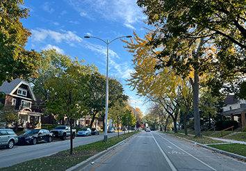
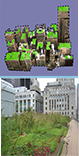
Activity 5 – Tree Canopies in Neighborhoods
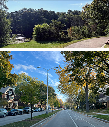
Tree canopies provide neighborhoods with shade, cool local temperatures, and help offset the urban heat island effect. Trees absorb carbon dioxide and release oxygen into the air. Leaves from trees filter particulate matter from the air, improving air quality; filter rainwater, slowing runoff; and reduce water pollution and flooding. Trees and their leaves create sound buffers between loud vehicles and machinery.
Tree cover provides shelter for birds, insects, and people.
Tree-lined streets improve walkability and neighborhood health, are visually appealing, and can lead to increased walkability and reduced stress for residents.
Every neighborhood should have trees!
Activity 6 – Key Districts in your Neighborhood
Your neighborhood will have records of the first buildings and homes. Often these first buildings and homes set the standards for creating the Neighborhood center, or place where people can come together to meet and to have special events. Centers may include a Village Hall, a Library, a Garden Center, a central park. Commercial districts will also have grocery stores, bakeries, hardware, restaurants, coffee shops, and bookstores. Districts may include elementary, middle, high school, and universities.
Activity 7 – Find your City's Neighborhoods
Review
- What is a key characteristic of neighborhoods according to the text?
- What is one way of getting to know your neighborhood?
- What is a suggested way to map your neighborhood?
- What often influences the form of a neighborhood?
- What are the three primary sources of inspiration for American house styles?
- What are corridors in relation to neighborhoods and districts?
- What is one purpose of neighborhood amenities according to the text?
- Which of the following is most closely connected to the design of neighborhoods and buildings?
Explore
- 25 best Denver neighborhoods
- 5 Minute Neighborhood
- Atlanta GA Neighborhoods
- Atlanta Neighborhoods
- Atlas of ReUrbanization
- Auburn Neighborhoods
- Australia's Neighborhoods
- Berlin 12 District Neighborhoods
- Berlin Neighborhoods
- Better Block
- Boston Commons
- Boston Neighborhood
- CHICAGO NEIGHBORHOODS
- City Green Tree Canopies
- Cleaning Up Philly 1 Block-At-A-Time
- Click That Hood
- CNU Project Data Base
- Congress for New Urbanism
- Copenhagen Neighborhoods
- Dallas Neighborhoods
- Effekt Danish Neighborhood Planning
- Floating Eco Community in Amsterdam
- Folded Map Project
- FOLDED MAP PROJECT CHICAGO
- Gauteng, South Africa
- Gehl Institute Public Life Tools
- Hong Kong's neighborhoods
- Honolulu Neighborhoods
- I Am Amsterdam
- Image of the City Kevin Lynch
- Johannesburg, South Africa Interactive Map
- London Neighborhoods
- London Neighborhoods
- Los Angelos Neighborhoods
- Mapping Neighborhood Patterns
- Milwaukee Neighborhoods
- Milwaukee Neighborhoods
- Milwaukees 190 Neighborhoods
- Native Indigenous Land Map
- Neighborhood Now Toolkit NYC
- Neighborhood Scavenger Hunt PDF
- Neighbor-Space
- Nequette Community Architecture and Design
- New York City Boroughs Maps
- New York City Neighborhoods
- OECD Better Life Index
- Paris 21 Arrondisements
- Paris Neighborhoods
- Portland Neighborhood Map
- Pretoria, South Africa Neighborhoods
- Rome Italy Neighborhoods
- San Francsico neighborhoods
- Seattle Neighborhoods
- Shanghai Neighborhoods
- Toky0 Neighborhoods
- Tokyo Neighborhoods
- Urban Anthropology History and future of Milwaukee Neighborhoods
- Video Boston Seaport transformed
- Video Celtic Age Roundhouse Village
- Video MPC Corridor Development Initiative
- Vienna Neighborhoods
- Walnut Way
- Washington, DC Neighborhoods
Relate
- Airport Design

- Air Quality

- Bathrooms

- Biodiversity

- Buildings like Bodies

- Building Types

- Bus Stop

- Circular Economy

- Cities

- Climate

- Collaboration

- Concrete

- Cultural Walks

- Energy

- Farmers Markets

- Food

- Forests

- Green Building

- Green Cities

- Green Home

- Green Roofs
- Green Schools

- Green Streets

- Grid

- Growing food

- Housing Styles

- Interior Design

- Interiority

- Kitchen Design

- Light Design

- Maps

- Nature Play

- Neighborhood
- Parks

- Place Experience

- Place Exploration

- Placemaking

- Playscapes

- Pocket Parks

- Public Space

- Roofs

- Skyscrapers

- Smart Cities

- Smart Grid

- Space Planning

- Streets

- Sunlight

- TIny House

- Topography

- Towns

- Tree Identification

- Urban Agriculture

- Urban Design

- Vernacular Architecture

- Water Conservation

- Water Quality

- Watershed

- Wayfinding

- Well Being

- Wetlands

- Work Places

- Zero Net Homes


All contents copyright © NEXT.cc. All rights reserved. Terms of Use